What evidence is there for ancient shorelines on Mars?
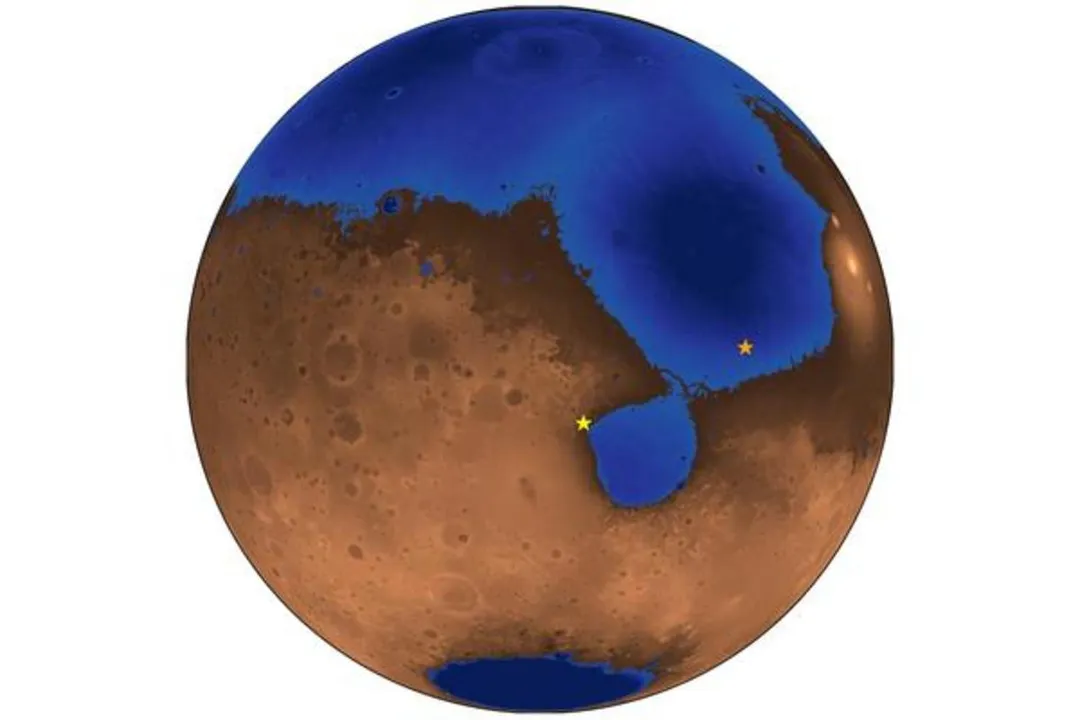
The ongoing investigation into the geological record of Mars frequently circles back to a profound possibility: that the Red Planet once hosted large bodies of liquid water, perhaps even a global ocean. This idea, known scientifically as the Mars Ocean Hypothesis, is supported by various features observed across the planet's surface that bear a striking resemblance to coastal formations on Earth. [3][5] Identifying definitive ancient shorelines is a key step in confirming how much water Mars held and for how long, which directly impacts our understanding of the planet's potential habitability in its ancient past. [6][7]
# Shoreline Traces
The primary evidence prompting these discussions comes from analyzing orbital imagery and data gathered by various Mars missions, which reveal layered sedimentary deposits and distinct topographical boundaries that look like ancient coastlines. [2][6] Researchers have focused their attention on large, low-lying northern plains that hypothetically could have been submerged beneath an ocean. [5] Specific investigations have centered on features like coastal plains, beaches, and the identification of specific sedimentary structures that only form in the presence of liquid water and wave action. [1][4]
One crucial piece of evidence centers on analyzing the sedimentary successions found in certain regions. For instance, sedimentary layers observed in the geological record have been interpreted as deposits laid down by tides or waves washing onto a beach. [4][8] The transition zones between ancient high-water marks and the higher surrounding terrain show specific geological characteristics consistent with shoreline processes. [7] In some analyses, researchers have mapped out potential sea-level lines based on these sedimentary features, proposing specific altitudes for the water surface across vast regions of the planet. [8]
A study published in the Proceedings of the National Academy of Sciences detailed the identification of geological evidence suggesting the presence of a standing body of water, potentially a sea or ocean, in the northern plains of Mars. [1] This evidence often involves studying the stratigraphy—the layering of rocks—to look for textures associated with fluid flow, like those created by wave agitation or deposition in a stable water level environment. [1] The sheer scale of these hypothesized ancient water bodies, if confirmed, suggests an ocean that would have covered a significant fraction of the planet's surface, perhaps as much as 30%. [4]
# Ocean Hypothesis
The Mars Ocean Hypothesis posits that early Mars, approximately 3 to 4 billion years ago, was warm enough and possessed a thick enough atmosphere to sustain liquid water on its surface rather than having it locked up as ice or lost to space. [3] If an ocean existed, it would have created a distinct boundary where water met the land, forming a shoreline that should, in theory, be preserved in the geology. [7] Scientists have looked for evidence of erosion patterns, sediment sorting, and ancient deltas that point toward sustained water bodies, not just fleeting floods. [5]
Some models suggest that water, perhaps supplied by ancient volcanism or asteroid impacts releasing subsurface ice, coalesced into a massive ocean in the vast Boreal region, sometimes referred to as Oceanus Borealis. [3] This proposed ocean would have been significantly different from Earth's contemporary oceans, perhaps being colder and largely ice-covered, or potentially existing in a mixed ice-liquid state, depending on the atmospheric pressure and temperature models used. [4] The existence of large, persistent bodies of water is an attractive concept because liquid water is fundamental for life as we understand it, making the search for ancient shorelines a proxy search for ancient life. [6]
It is interesting to consider the energy required to form features recognizable as beaches. On Earth, wind-driven waves and tides are major agents of sediment transport and sorting along coasts. For Martian shorelines to retain evidence of wave action, the ancient Martian atmosphere must have been dense enough to transmit sufficient energy to the water surface, even if the water itself was significantly colder than terrestrial seawater. [2] If the water was mostly ice-covered, wave action would be muted, suggesting that the most convincing evidence should come from areas where liquid water was frequently exposed, perhaps during warmer periods or near volcanic heat sources.

# Conflicting Signals
While tantalizing evidence exists, the interpretation of Martian geology is complicated by the planet’s long history of impacts, shifting sands, and ancient volcanic activity, all of which can mimic or obscure coastal features. [5][9] Furthermore, observations are not entirely uniform across the planet, leading to ongoing scientific debate about the extent and certainty of any ancient ocean. [9]
A notable example of conflicting data comes from analyses of new images, where researchers have not found the expected geological signatures of ancient shorelines in certain key areas previously believed to be prime candidates. [9] Specifically, images from the HiRISE camera onboard the Mars Reconnaissance Orbiter, when analyzed in detail, sometimes fail to show the definitive, planet-wide sedimentary sequences or clear boundary features that would be expected if a large ocean had covered an area for a substantial period. [9] This lack of corroboration in certain targeted spots tempers the enthusiasm, suggesting that if an ocean did exist, it might have been shallower, existed for a much shorter time, or left behind a more ephemeral signature than initially hoped. [9]
This tension highlights a fundamental challenge in planetary science: distinguishing between massive, ancient floods (which could carve canyons and deposit large deltas) and standing, long-term water bodies (which create consistent, horizontal shoreline markers). [1][5] A large, deep ocean would leave a very specific, nearly level topographical demarcation that would persist through subsequent erosion, whereas catastrophic outflow floods would result in more chaotic, rapidly cut features. [8] The disagreement often boils down to the precise interpretation of sedimentary textures when viewed from orbit, where fine-scale details that distinguish a beach from a flood plain are often blurred. [2]
# Geological Markers
The strength of the shoreline argument often rests on the identification of specific landforms that require water and wave action over time. These markers are frequently categorized by the energy level needed to create them. [1]
| Feature Type | Required Energy/Condition | Significance for Mars |
|---|---|---|
| Gravel Deposits | Moderate wave energy, sustained water presence | Indicates abrasive action typical of beach faces. [4] |
| Layered Sediments | Stable water level, deposition over time | Suggests sea level fluctuations or consistent coastal boundaries. [8] |
| Coastal Plains | Large, standing body of water | Defines the boundary of the hypothesized ocean basin. [3][5] |
| Wave-Formed Ripples | Direct interaction with moving surface water | Strongest evidence for liquid water interaction at the surface. [2] |
One way scientists attempt to verify these features is by looking for specific alignments of ancient river valleys or outflow channels that appear to terminate abruptly at a mapped shoreline, as if they are flowing into a large basin rather than just across a plain. [6] If an ocean occupied the northern basin, the deltas formed by rivers flowing from the southern highlands should all point toward that basin and terminate at a consistent elevation marker. [7] The presence of shorelines helps scientists reconstruct the paleotopography—the topography of Mars as it was billions of years ago—by effectively erasing the younger deposits and lava flows to reveal the underlying water level. [8]
Considering the data resolution, it's worth noting that what appears to be a clear horizontal line from a few hundred kilometers up might, upon closer inspection by a rover, reveal itself to be a series of ancient, tilted fault lines or volcanic intrusions. [1] This necessitates cross-referencing data from multiple instruments—topography from orbiters, mineralogy from landers, and high-resolution imaging—to build a truly convincing case. [2][9] The process is inherently conservative; strong evidence requires that all alternative geological explanations are less plausible than the ocean hypothesis.
# Climate Implications
If ancient shorelines are indeed confirmed, the implications for early Martian climate are immense. A body of water large enough to form a persistent ocean would have required a significantly warmer and wetter past than the current frigid, dry state. [4] Such an ocean would have acted as a massive heat reservoir, potentially moderating surface temperatures and influencing atmospheric dynamics in ways that might have permitted microbial life to gain a foothold. [3][6]
The sheer volume of water necessary to create an ocean covering the northern plains is staggering, possibly amounting to a global layer several kilometers deep if it were distributed evenly. [4] The survival of this water suggests a stronger, denser atmosphere than Mars possesses today, capable of maintaining sufficient pressure to keep water liquid. [3] Confirming the shorelines helps constrain the minimum atmospheric pressure and temperature conditions required during that epoch, moving the discussion from purely theoretical climate modeling toward evidence-based geological constraint. [7]
For example, if the shorelines are consistently found at an elevation that indicates only a regional sea, perhaps occupying only the lowest craters and basins, the required atmospheric change would be less drastic than for a planet-encircling ocean. [5] Conversely, finding a continuous, high-elevation shoreline tracing the edge of the northern lowlands demands a far more dramatic shift in Martian climate history. This is why pinning down the exact elevation of any identified beach deposit is scientifically critical; it directly informs the models of ancient atmospheric density. The search for these markers is, therefore, as much a test of ancient climate theory as it is a search for ancient geography. [8]
# Future Perspectives
The search for definitive proof continues, driven by current and upcoming missions. Future efforts will likely focus on deploying specialized instruments, perhaps advanced ground-penetrating radar or high-resolution ground cameras on rovers, to analyze the sedimentary material in situ for the telltale signs of ancient wave sorting that orbiters cannot definitively resolve. [1][2]
One actionable path forward involves developing improved techniques to model the effects of ancient tectonic shifting and subsequent resurfacing on the expected elevation of a shoreline. [8] If an ocean existed, the crust beneath it would have been depressed by the water's weight—a process called isostatic adjustment. When the water disappeared, the crust would rebound, potentially shifting the elevation of the original shoreline marker over time. Accounting for this rebound, if it occurred, would adjust the calculated sea level, which is a complex parameter to integrate into current geological mapping efforts. [7] Failing to account for this crustal flexing might lead researchers to either over- or under-estimate the total volume of water once present.
Ultimately, while the planet has revealed substantial evidence of liquid water in its past—in the form of river valleys, minerals that form in water, and possible lakebeds—the existence of a true, large-scale ocean remains an interpretation, albeit a powerful one, resting on features that strongly resemble ancient beaches. [6] The debate persists because the Martian environment is unforgiving, gradually erasing the signatures of its watery youth. [9] The confirmation of unmistakable, continuous shorelines, validated across multiple geological terrains and aligned with isostatic models, will be the moment the Mars Ocean Hypothesis transitions from compelling theory to established planetary fact.
Related Questions
#Citations
Ancient ocean coastal deposits imaged on Mars - PNAS
Ancient beaches testify to long-ago ocean on Mars - Berkeley News
Mars ocean hypothesis - Wikipedia
Evidence of Ancient Beaches Shows Us a Mars With Large, Ice-Free ...
Evidence for an Ancient Martian Ocean - AAS Nova
Traces of ancient ocean discovered on Mars | Penn State University
Geological evidence points to ancient ocean in Mars' northern ...
Evidence For An Ancient Sea Level On Mars - Astrobiology Web
New Mars Images: No Evidence of Ancient Ocean Shorelines