What are the evidence of ancient shoreline on Mars?

The crimson dust that defines modern Mars belies a far more dynamic and wet past. For decades, scientists have debated the tantalizing possibility that the planet’s vast northern lowlands were once submerged under a gargantuan body of liquid water, an ancient ocean sometimes referred to as Oceanus Borealis. While the idea has been a cornerstone of Martian geological speculation since early orbital data, recent discoveries, particularly from China’s Zhurong rover, are moving the concept from hypothesis to potentially firm evidence, revealing the structure of those long-vanished coastlines beneath the surface.
# Early Hints

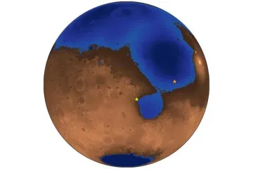
The foundation for the Mars ocean hypothesis rests largely on the planet's dramatic topography—the Martian dichotomy. The northern hemisphere is notably smooth and lies significantly lower, sometimes 4 to 5 km below the mean planetary elevation, compared to the heavily cratered, rugged southern highlands. This massive basin, known as Vastitas Borealis, is the prime location for a primordial sea.
Initial clues emerged from images captured by the Viking orbiters in 1976, which showed features thousands of kilometers long that resembled coastlines bordering this northern depression. However, these observations immediately sparked a major scientific sticking point. On Earth, sea level is defined by a consistent, level boundary across vast distances. Martian orbiters, using data like that from the Mars Orbiter Laser Altimeter (MOLA), later revealed that these proposed shorelines varied wildly in elevation, rising and falling by as much as 10 kilometers. This apparent irregularity provided a strong argument against a single, global ocean, suggesting instead that features might be the result of complex erosion patterns or localized seas.
To reconcile this, some researchers turned to planetary physics. A geophysical model proposed in 2007 suggested that massive redistribution of mass on Mars, such as the growth of the enormous Tharsis volcanic region about 3.7 to 4 billion years ago, could have altered the planet's rotation axis—a process called true polar wander. Such a shift in the planet’s spin axis would effectively tilt the surface, causing a once-level ancient shoreline to appear highly undulating in today’s topographical maps. This mechanism provided a physical explanation for the irregularity, keeping the ocean hypothesis alive.
# Subsurface Signatures

While orbital data offered evidence of where water might have been, definitive proof required looking beneath the current, heavily weathered surface layers. Researchers studying areas like Aeolis Dorsa identified sedimentary accumulation and structures consistent with deltas being fed into a large standing body of water. Yet, the most compelling in situ evidence has recently arrived from the Zhurong rover, which explored the southern Utopia Planitia region.
Zhurong, operational for one year between May 2021 and May 2022, used its Rover Penetrating Radar (RoPeR) to peer up to 80 meters beneath the regolith. This GPR system, operating at low frequencies, is designed to penetrate deep enough to find buried relics of past water activity. The results, published in PNAS, were striking: Zhurong imaged extensive, buried layers of material that exhibit classic signatures of beaches.
The radar profiles revealed a total of 76 dipping reflectors buried between 10 and 35 meters deep. Crucially, these layers all inclined consistently toward the northern lowlands, with inclinations generally ranging from 6° to 20°, averaging about 14.5°. These dipping structures are interpreted as prograding coastal sediments—material deposited as waves carried sand shoreward, building up the beach face layer by layer.
On Earth, the formation of such layered, dipping beach deposits requires sustained wave action and tidal currents to transport sediment to the shoreline. The fact that the Zhurong site, located hundreds of kilometers from the nearest previously proposed shoreline, showed these features over a traverse of about 1.3 km suggests the presence of a large, persistent, ice-free ocean. This influx of sediment also implies the existence of primary sources, likely rivers, situated far enough away that their immediate floodplains were not imaged, pointing to a hydrologically active region sustained over a significant time.
# Geological Comparison
The discovery pivots on comparing these Martian radar readings with terrestrial analogs. Terrestrial coastal deposits imaged with GPR show similar dipping patterns, typically falling between 4° and 26°. The Zhurong data fits perfectly within this range. Furthermore, researchers were able to estimate the relative permittivity (a measure of how electromagnetic waves propagate) of the buried material, finding values between 3 and 7. This range rules out common alternative origins:
- Lava flows typically have higher relative permittivities, around .
- Aeolian (wind-blown) deposits like dunes would show far more variation in dip angles and exhibit cross-bedded features, which were absent.
The interpretation that these are beach deposits implies that the ancient Martian environment was not only wet but ice-free enough for waves to form and distribute sand-like particles. A lake, even a large one like those thought to exist in Gale Crater where the Curiosity rover operates, might produce ripples, but forming extensive, prograding beaches requires the vast fetch (distance over water) that only an ocean can provide. The fact that these deposits are buried suggests the liquid water later vanished, and the coastline was subsequently covered by subsequent layers of dust, impact ejecta, or volcanic ash over the ensuing billions of years.
The evidence gathered by Zhurong suggests a period when the atmosphere was thick enough to trap solar heat, allowing for surface water stability—a warm and wet climate that is now long gone.
The significance of these geological markers can be visualized by comparing the implied duration. If Martian deposition rates mirrored analogous coastal sedimentary deposits on Earth, the formation of the observed to 40 cm per thousand years rate could imply the ocean persisted for tens of millions of years in that region. This timeframe is geologically significant when considering the origins of life.
One analytical comparison that emerges from these findings is the necessary stability of the water reservoir. If Mars had simply experienced temporary meltwater events, the sediment influx from distant rivers would likely not have maintained a net progradation (outward building) of the shoreline over millions of years. Shorelines formed by local erosion would reach an equilibrium shape and slow down sediment contribution; sustaining the observed deposition requires a persistent, large-scale input system—the hallmark of a massive, stable ocean basin.
# Implications for Life
The presence of an ancient, ice-free ocean fundamentally changes the context for the search for extraterrestrial life. On Earth, life appeared relatively quickly in the early oceans. If Mars experienced similar, life-favorable conditions—liquid water, a thicker atmosphere, and potentially stable tidal environments—it stands to reason that life could have originated there concurrently.
The scientific community views these beach deposits as prime real estate in the search for biosignatures. Where there are ancient shorelines, there is a physical interface between air and shallow water, a zone long considered a potential cradle for abiogenesis on our own world.
While missions like Curiosity and Perseverance have confirmed the existence of ancient lakes and rivers, an ocean suggests a much larger, more stable, and longer-lived watery environment. This increases the probability that life could have not only originated but also sustained itself for a measurable period.
The stratigraphic methods used to identify these buried beaches also offer a path forward for future exploration. Since the Zhurong findings showed that the most compelling evidence lies 10 to 35 meters below the current surface, finding physical proof of life—perhaps fossils or chemical signatures—would require digging significantly deeper than current surface analysis allows.
A constructive consideration for future sample-return missions focuses precisely on these radar anomalies. Instead of solely sampling exposed sedimentary rocks in canyons or deltas, a high-priority objective should be identifying locations where a meteor impact or recent erosion has exposed a cross-section of the subsurface layers identified by GPR. Focusing landing sites near these buried foreshore deposits—the specific boundary layers where wave energy dropped sediment—would maximize the chance of retrieving material that was actively participating in the aquatic ecosystem before it was sealed away.
# The Fate of the Water
If Mars once hosted an ocean large enough to form features like these, where did all that water go? The debate continues over the ultimate fate of the Martian hydrosphere.
The current climate is too cold for liquid water to flow freely on the surface. Scientists generally agree on two main pathways for its disappearance:
- Atmospheric Escape: As Mars lost its global magnetic field, the solar wind stripped away much of its atmosphere, reducing the pressure so that surface water could only exist as ice or vapor, with the vapor eventually escaping to space through processes like photodissociation. This loss is thought to have been accelerated by dust storms carrying water vapor high into the atmosphere.
- Subsurface Storage: A significant portion of the water likely sublimated or was incorporated into minerals within the crust as the surface froze. Recent seismic data from the InSight lander suggests substantial liquid water still exists deep underground, perhaps enough to cover the entire planet with an ocean between 520 and 780 meters deep if brought to the surface, though this water is currently locked in fractures many kilometers down.
The discovery of fossilized beaches confirms that at least one vast body of water existed long enough to create complex coastal geology, lending significant weight to the theory that early Mars was a planet capable of sustaining large, dynamic liquid environments. The evidence of these ancient, ice-free shorelines ensures the Red Planet remains the most compelling location in our solar system to continue the quest for proof that life arose elsewhere in the cosmos.
# Unresolved Dynamics
Even with compelling subsurface evidence, certain complexities remain that Mars research must address to fully paint the picture of this ancient aquatic world. The role of tsunamis, for instance, offers a dynamic counterpoint to the gentle lapping of waves implied by the Zhurong beach deposits. Asteroid impacts into the ancient northern ocean are thought to have generated massive tsunamis—some waves estimated between 10 and 120 meters high—that would have churned and reshaped existing coastlines. This suggests the planet’s water history involved both tranquil, long-term shoreline accretion and cataclysmic, high-energy resurfacing events.
Another area of ongoing inquiry relates to the atmospheric conditions required. A atmosphere as thick as present-day Earth’s, perhaps supplemented by other greenhouse gases like methane, would have been necessary to warm the planet enough to prevent water from instantly freezing. Confirming the precise composition and longevity of that thicker atmosphere remains a key piece of the puzzle that ties the ocean's existence to the planet's climate evolution. Future missions, perhaps those that aim to return Martian samples to Earth, will be vital in providing the detailed compositional analysis needed to close this chapter on the watery history of Mars.
Related Questions
#Citations
Ancient ocean coastal deposits imaged on Mars - PNAS
Ancient beaches testify to long-ago ocean on Mars - Berkeley News
Mars ocean hypothesis - Wikipedia
Evidence of Ancient Beaches Shows Us a Mars With Large, Ice-Free ...
China's Mars rover Zhurong finds possible shoreline of ancient Red ...
Evidence for an Ancient Martian Ocean - AAS Nova
Traces of ancient ocean discovered on Mars | Penn State University
Scientists have found proof of an ancient Martian ocean. It could ...