How many geostationary satellites are required for global coverage?
The simple question of how many geostationary satellites are needed to blanket the Earth reveals a fascinating interplay between orbital mechanics, practical engineering, and the geometry of our planet. The answer, surprisingly concise for near-global coverage using the Geostationary Earth Orbit (GEO), rests on the number three. However, this number comes with significant caveats concerning the planet's extreme latitudes, prompting the need for other types of orbits to achieve truly universal communication links.
# Orbit Mechanics
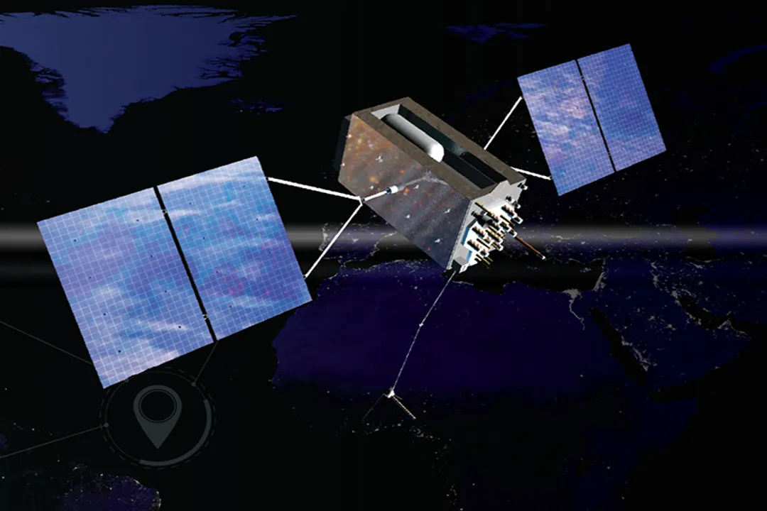
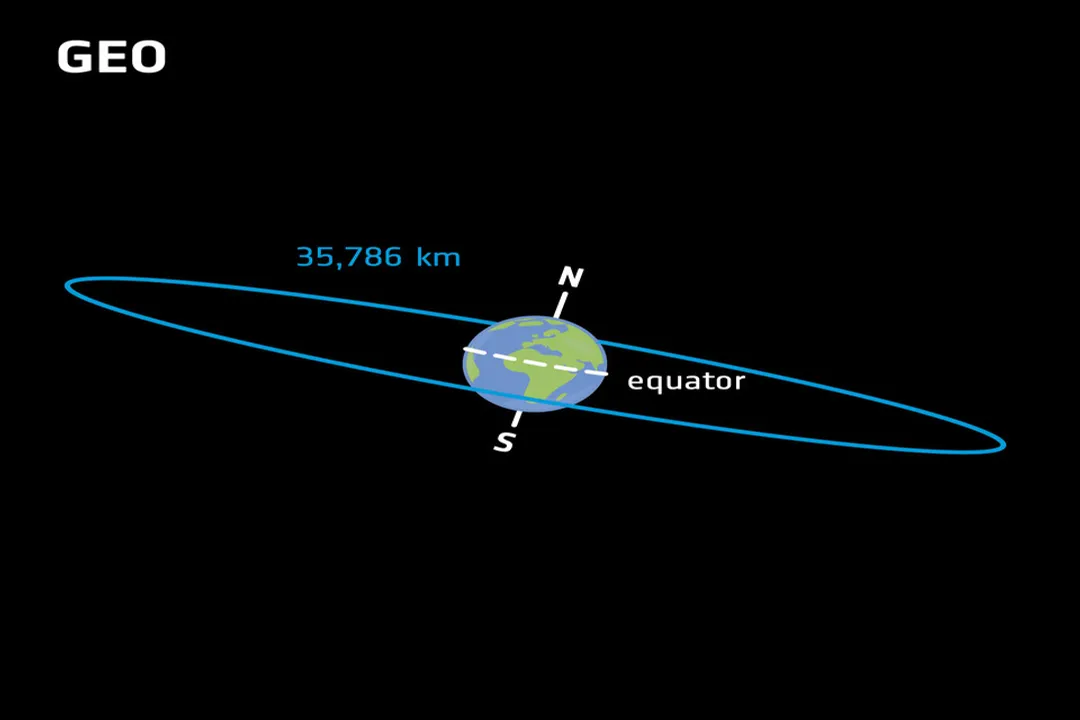
To understand the required number, we must first establish what defines a geostationary satellite. This specific type of orbit, often referred to as GEO, sits at an altitude of approximately $35,786$ kilometers above the Earth's equator. The critical feature of GEO is that the satellite's orbital period matches the Earth's rotation period—24 hours. This synchronization causes the satellite to appear fixed in the sky when viewed from the ground. For terrestrial communication systems, this fixed position is highly advantageous, as ground antennas do not need complex tracking mechanisms; they can be pointed permanently at the satellite.
The geometry of this placement is crucial. A satellite in GEO circles directly above the equator. This equatorial requirement is the source of the fundamental limitation for achieving truly global coverage from this altitude alone.
# Minimum Count
For the purpose of providing television transmission or general communication coverage across the majority of populated areas, the theoretical minimum constellation size for GEO is generally considered to be three satellites. These three assets must be spaced around the equator at precise intervals.
The Earth is a sphere, totaling of longitude. To maximize the shared coverage footprint between satellites and minimize the gaps between them, the three satellites are positioned to divide this circle equally.
# Equator Spacing

The necessary spacing works out to divided by three, resulting in a separation of longitude between each satellite. Imagine looking down onto the Earth's North Pole; if you drew three lines from the center of the Earth out to the equator, separated by 120 degrees, the sub-satellite points of the three GEO satellites would sit on those lines. The coverage area of each satellite overlaps with its neighbors, ensuring that a user on the ground remains within line-of-sight of at least one satellite at all times across the covered region.
This configuration of three is remarkably efficient for the vast majority of human habitation. For instance, three strategically placed satellites can provide coverage extending up to approximately latitude both north and south of the equator. This range effectively covers nearly all major landmasses and population centers across North America, South America, Europe, Africa, and Asia.
To offer some perspective on this geometric efficiency, consider the physical distance along the equator separating the centers of coverage for these three satellites. At the GEO altitude, the Earth's equatorial radius is about $6,378$ kilometers. The distance along the arc between two points separated by on a circle whose radius is $42,164$ km (the GEO radius plus Earth's radius) is significant, yet the visible overlap area achieved by the antenna patterns (the "footprint") is engineered to maintain continuity across that span.
# Polar Gap
While three satellites provide excellent coverage for most of the world, they fail one crucial test: reaching the poles. Because GEO satellites orbit only on the equatorial plane, their ability to provide line-of-sight communication diminishes rapidly as one moves toward the north and south poles.
At latitudes approaching North or South, the satellite appears so low on the horizon that the signal path becomes excessively long, leading to high signal attenuation, and the curvature of the Earth begins to obscure the satellite entirely from view. Therefore, the "global coverage" provided by a purely GEO constellation is strictly near-global. Regions around the North and South Poles—places like northern Greenland, the Arctic Ocean, and the Antarctic continent—are effectively outside the service footprint of any single geostationary satellite.
# Other Orbits
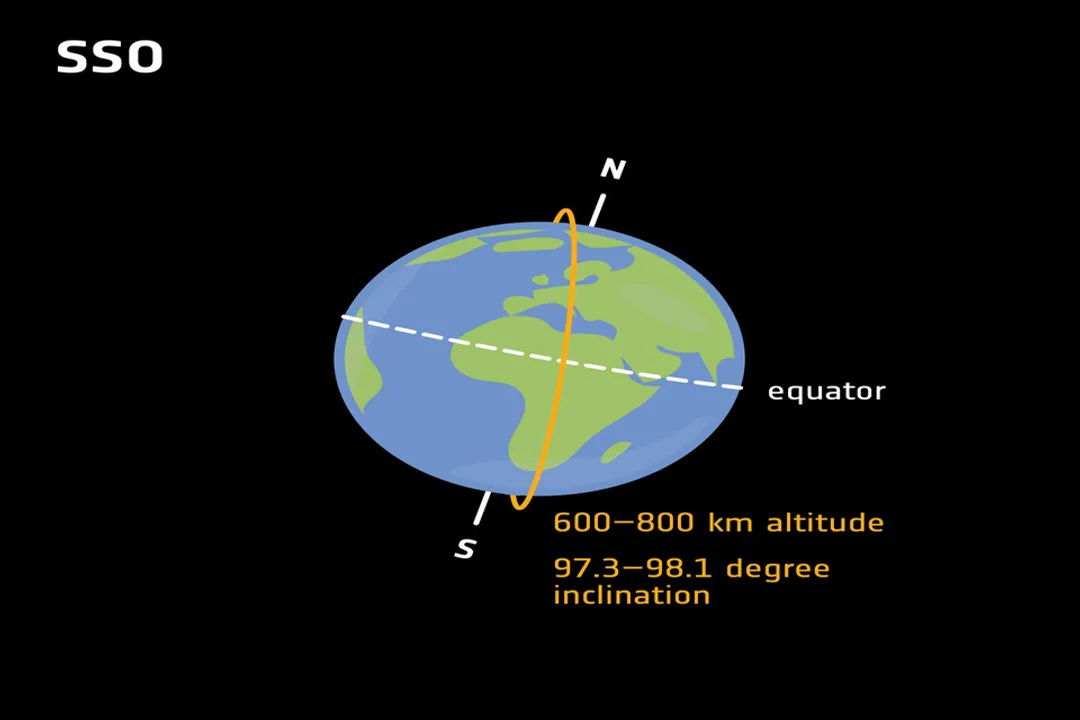
When the requirement shifts from near-global service, especially to include the poles, the architecture must fundamentally change, often requiring higher numbers of satellites in different orbits, such as Low Earth Orbit (LEO) or Medium Earth Orbit (MEO). These non-geostationary orbits are essential for achieving true ubiquity.
The differences in satellite counts become stark when comparing GEO to these other orbits, particularly in the context of Global Navigation Satellite Systems (GNSS), such as the American GPS system. GNSS relies on MEO satellites, which orbit at a much lower altitude than GEO and move rapidly relative to the ground. Because they move, many satellites are needed to ensure that any point on Earth always has several satellites in view for accurate triangulation.
For a GNSS like GPS, the nominal constellation size is often cited as 31 satellites, though systems are designed to operate with as few as 24 satellites to ensure continuous coverage across the entire globe, including those hard-to-reach polar zones. These systems use multiple orbital planes (e.g., six planes for GPS) to achieve this global geometry, a complexity unnecessary for the fixed-point communication offered by GEO.
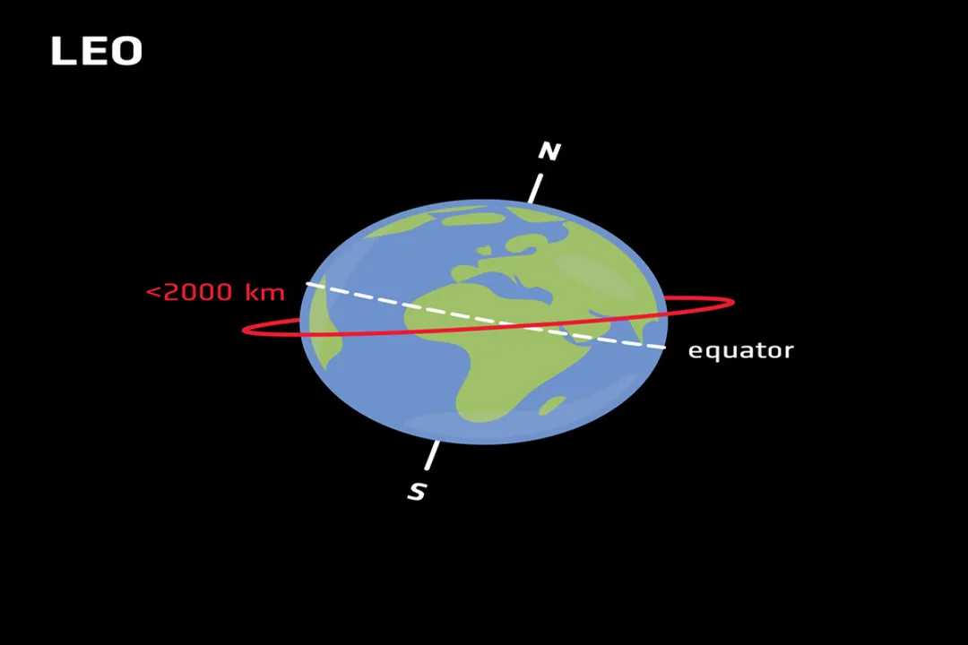
# GEO Versus LEO
The distinction in numbers ($3$ for GEO vs. $24+$ for MEO/GNSS) directly reflects the trade-off between altitude and required quantity. A LEO satellite orbits much closer to Earth—sometimes just a few hundred kilometers up. While this lower altitude means signals travel a shorter distance, leading to lower latency (a benefit for modern internet applications), the satellite moves extremely fast across the sky.
To provide continuous coverage with LEO satellites, a large constellation is mandatory because each satellite is only in view of a specific area for a short period before it moves out of range. The required number of LEO satellites to cover the Earth completely far exceeds the few needed for GEO, though LEO constellations can easily cover the poles, which is their key advantage over GEO for true global service.
# Operational Deployment
While the theoretical minimum for GEO is three, operational systems rarely use just three satellites unless they are providing highly specialized, narrow-beam services or are part of a shared orbital arc system. A common operator, such as a major broadcaster or a regional telecommunications provider, will typically deploy more than three for redundancy, service area expansion, or to provide higher throughput capacity.
Consider a hypothetical scenario for a regional broadcaster needing to cover Western Europe and the Middle East using the spacing model. They might place their first satellite centered over the prime meridian ( E) to maximize coverage over Western Europe and Africa. The second would be at E, covering much of Asia, and the third at E (or W), covering the Atlantic and the Americas. This arrangement works for communication links. However, if that same broadcaster needed to guarantee service to an oil rig operating above North latitude—just outside the theoretical limit—they would immediately find the GEO solution inadequate and would need to supplement their GEO assets with a separate LEO service or switch their entire infrastructure to a non-GEO constellation for that specific application. This highlights that the "minimum number" is context-dependent: three for the bulk of the inhabited world, but potentially many more (or a different system entirely) for complete, pole-to-pole service.
# Capacity Versus Coverage
Another layer of complexity arises when differentiating between coverage and capacity. The three-satellite model addresses coverage—ensuring that an antenna on the ground can see a satellite. It does not address capacity—how many users that satellite can support simultaneously.
As user demand increases—for example, with the proliferation of HD television broadcasting or high-speed data demands—a single satellite footprint may become saturated. To maintain service quality (throughput) over the same geographical area, operators must deploy more satellites, effectively increasing the minimum operational fleet size well above the theoretical three required just to touch the ground everywhere. This means that a real-world commercial GEO system aiming for superior service quality over the latitude boundary will likely use four, five, or more satellites, often clustered closely together to re-use frequencies or offer diverse routing options, even if geometrically three could theoretically cover the zone.
# Engineering Constraints
The GEO belt, while beneficial for its static nature, is a crowded, highly regulated environment. The separation is the ideal minimum spacing for interference avoidance, but many commercial operators use tighter spacings, sometimes as little as to , to maximize the number of operators who can share the arc. This close packing requires incredibly precise station-keeping by the satellite operators to prevent adjacent satellites from interfering with each other’s uplink or downlink signals. When operators are planning capacity expansion, they are often limited not by the physics of coverage (where three is enough), but by the regulatory limits on orbital slot density and radio frequency interference management.
In summary, for the specific task of maintaining line-of-sight communication using the inherent advantages of Geostationary Earth Orbit, the minimum requirement is decidedly three satellites spaced apart. This solution covers nearly all densely populated regions but leaves the polar caps inaccessible. True global reach, including those high latitudes, necessitates adopting constellations based on MEO or LEO orbits, which inherently demand a much larger operational fleet, often numbering in the dozens, like the $24+$ required for systems such as GPS.
Related Questions
#Citations
[Solved] The minimum number of satellites required for worldwide
How many minimum number of geostationary satellites are required ...
Global Navigation Satellite System [Explained]
GNSS - Global Navigation Satellite System - NASA Earthdata
ESA - Types of orbits - European Space Agency
Low Earth Orbit (LEO) Satellites vs. Geostationary Satellites - Medium
How can 30-40 GPS satellites cover all of the world's GPS needs?
A guide: GEO, LEO and MEO Satellites - OceanWeb Ltd
How can 30-40 GPS satellites cover all of the world's GPS needs?