What is the joint mission of NASA and ISRO?

The collaboration between the National Aeronautics and Space Administration (NASA) and the Indian Space Research Organisation (ISRO) represents one of the most significant international efforts in Earth science observation today, crystallized in their joint satellite project, the NASA-ISRO Synthetic Aperture Radar (NISAR) mission. This mission is not merely a routine deployment of new hardware; it is the first dedicated, joint satellite endeavor between the United States and India, aiming to provide an unprecedented, detailed look at our planet’s dynamic surface features. The objective centers on utilizing advanced radar technology to continuously monitor Earth, giving scientists powerful tools to track geological events and environmental shifts that impact communities globally.
# Mission Purpose
The primary joint mission articulated by both agencies centers on Earth system science, using Synthetic Aperture Radar (SAR) technology to map the surface of the globe. The data collected will be invaluable for addressing critical environmental questions and understanding natural hazards.
Specifically, the NISAR satellite is designed to provide high-resolution, three-dimensional imaging to track changes on Earth’s surface over time. This capability allows researchers to measure subtle movements that are often invisible to the naked eye, which is crucial for hazard assessment. Key phenomena targeted by the mission include:
- Tracking tectonic plate movement and ground deformation related to earthquakes.
- Monitoring volcanic activity and associated ground uplift or subsidence.
- Assessing the stability of landscapes prone to landslides.
- Observing changes in the structure and volume of ice sheets and glaciers.
- Measuring ground subsidence caused by factors like excessive groundwater withdrawal.
The mission's commitment to providing global coverage is emphasized by the plan to observe key areas, including those related to global warming, such as areas susceptible to sea-level rise and melting glaciers. This commitment to broad, impactful science underscores the mission's role in addressing pressing global challenges using space-based technology.
# Dual Radar System
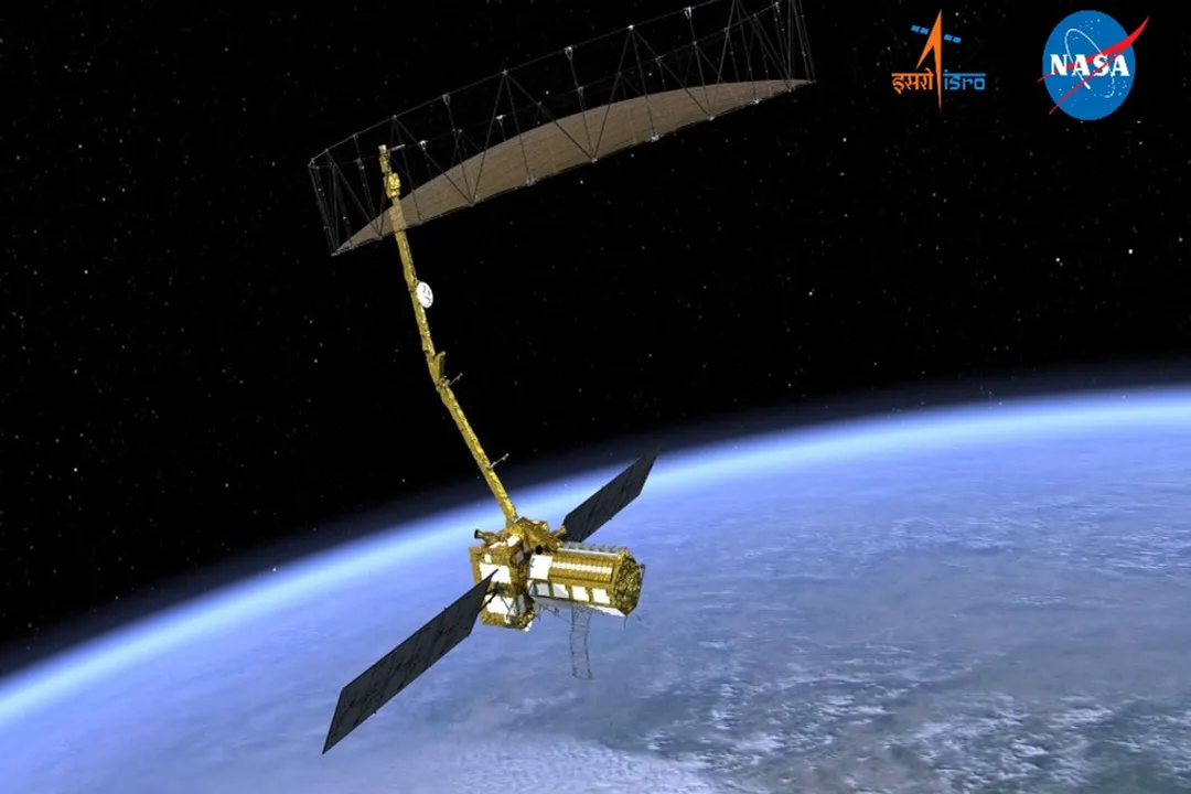
What sets the NISAR mission apart scientifically is its sophisticated instrumentation, which employs two distinct radar frequencies operating in tandem. This dual-frequency approach is a cornerstone of the mission's design, maximizing the information gathered from a single orbital pass.
The satellite hosts two main instruments:
- NASA’s L-band SAR: Operating at a longer wavelength, this instrument is designed to penetrate dense vegetation, allowing it to see changes in the soil and underlying ground structure beneath forests or agricultural canopy.
- ISRO’s S-band SAR: This instrument uses a shorter wavelength that is more sensitive to surface changes in areas with less or thinner vegetation cover.
The ability to capture measurements across both L-band and S-band from a single platform represents a significant step forward in remote sensing precision. While instruments can be flown sequentially on different missions, having both sensors integrated onto one spacecraft ensures perfect temporal registration—meaning the L-band data and the S-band data capture the exact same piece of the Earth at the exact same moment. This simultaneity eliminates potential errors that arise from trying to match data collected hours or days apart by separate satellites, providing a scientifically cleaner basis for comparison and analysis of surface displacement. The combined dataset allows scientists to untangle complex environmental signals, such as distinguishing between surface change due to soil moisture fluctuation versus actual tectonic movement.
# Collaborative Contributions
The successful realization of NISAR involved a complex division of responsibilities, highlighting a deep technical partnership between the two space agencies. Each country took ownership of distinct, critical components of the overall system.
NASA’s contributions to the project were substantial, encompassing the delivery of the L-band Synthetic Aperture Radar instrument itself. Furthermore, NASA was responsible for providing the spacecraft bus, which forms the main body and support structure of the satellite, along with the high-speed data recorders necessary for capturing the massive amounts of information generated by the radar systems. NASA also developed the associated ground data systems required for processing and distributing the data to the global scientific community.
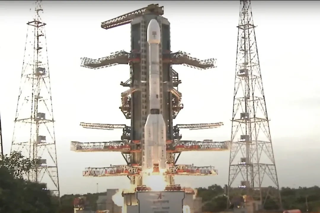
ISRO, on the other hand, provided the S-band SAR instrument. Crucially, ISRO also holds responsibility for the launch segment of the mission. The satellite is slated to launch aboard India's Geosynchronous Satellite Launch Vehicle (GSLV) Mk II rocket from the Satish Dhawan Space Centre in Sriharikota, India. This division of labor ensures that the strengths of both agencies—NASA's advanced instrumentation and ISRO's launch capability and indigenous S-band technology—are brought to bear on a single scientific objective.
# Assembly and Data Processing
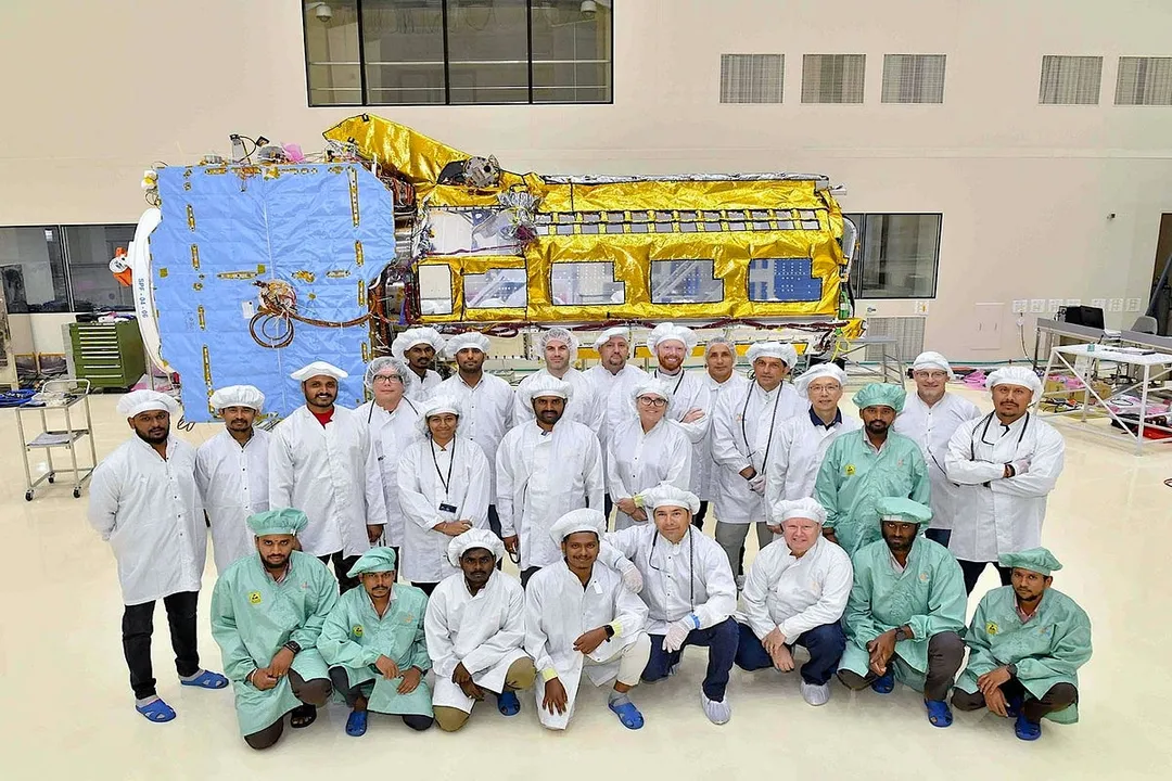
The integration of these complex components represents a major milestone in cooperative space engineering. The final assembly, integration, and testing (AIT) of the entire NISAR satellite structure took place in Bengaluru, India. This demonstrates a mature level of technical trust, as the core hardware provided by both nations was brought together for final verification in an ISRO facility.
Once in orbit, the data handling presents another area of shared responsibility. The radar systems are designed to generate significant volumes of data. The mission is structured so that the data processing and distribution will be a collaborative effort, ensuring accessibility to researchers worldwide. The dual-frequency data, once processed, will yield data products that are highly valuable for applications in disaster management and resource planning, potentially leading to improved early warning systems across various vulnerable regions. The expected data release is intended to benefit scientists globally, making this a truly international scientific asset.

# Geopolitical Significance
Beyond the clear scientific merit, the NISAR mission carries a significant weight as a demonstration of high-level international scientific partnership in space technology. In an era where space exploration and technology development can sometimes be characterized by competition, a mission of this magnitude, built and managed jointly, signals a commitment to shared global stewardship. The success of NISAR sets a precedent for future, perhaps even more complex, joint missions, proving that two distinct national space programs can effectively merge resources, timelines, and technical expertise to achieve a singular, ambitious goal that serves planetary health.
The investment required for a mission carrying two state-of-the-art instruments represents billions of dollars of combined effort and planning, an undertaking that often exceeds the capacity or immediate priority of a single nation’s budget for a specialized Earth observation task. For instance, while both agencies operate SAR systems, the specific combination of L-band capability from one partner and S-band from the other, integrated onto one platform, creates an asset that delivers more scientific value per launch than two separate, staggered missions might achieve. This synergy in resource pooling is an often-overlooked efficiency gain in large-scale space science.
The operational structure, where ISRO manages the launch vehicle and NASA manages parts of the instrumentation and ground systems, also suggests an established protocol for managing risk and technical dependencies across borders. When dealing with hardware operating in the harsh vacuum of space, the ability of teams located thousands of miles apart to troubleshoot and manage the asset—even before launch—speaks to a high level of established trust and procedural alignment between the two organizations, building on decades of prior cooperation in space endeavors. This joint operational model itself is a valuable outcome, regardless of the scientific data retrieved.
# Monitoring Earth’s Structure
To fully appreciate the scale of monitoring NISAR provides, it is helpful to contextualize the magnitude of movement the satellite is designed to detect. Ground displacement, whether caused by seismic activity or human factors, can be measured in millimeters over periods of time. The radar technique, called Interferometric SAR (InSAR), compares radar images taken at different times to detect these minute shifts in distance to the ground.
Consider a scenario like the Central Valley in California, a region historically reliant on intensive groundwater pumping. Over decades, this extraction can cause the land surface to compact and sink, a process known as subsidence. NISAR’s ability to map this sinking, particularly in areas covered by vegetation which obscures traditional ground-based measurements, offers local water managers a precise, quantifiable tool to enforce sustainable pumping limits. If a region subsides by, say, 2 centimeters over a year, that measurement, derived from the combined L- and S-band returns, informs decisions on water allocation that directly impact agricultural viability and infrastructure stability in that area.
Similarly, when a major earthquake strikes, the immediate scientific response involves mapping the slip along the fault line. While ground-based GPS can provide localized measurements, a satellite system like NISAR offers a wide-area, high-density map of the deformation field across the rupture zone. This comprehensive view is essential for rapid structural damage assessment and long-term models of seismic hazard zones.
The data products from NISAR will extend far beyond the immediate geological applications. For instance, the detailed surface maps contribute to better calibration of global climate models by providing accurate topographical data and understanding how mass balance changes in polar regions. This interconnection between near-surface process monitoring and large-scale climate studies demonstrates the cross-disciplinary value embedded in this single mission. The ability to measure forest structure using the L-band, for example, has direct implications for carbon accounting—a critical component of climate change mitigation efforts globally.
The dedication to launching this highly advanced instrument via the GSLV Mk II underscores ISRO's continuing evolution as a major launch provider capable of supporting highly complex, heavy international payloads. The reliability and capacity of the GSLV are central to the mission's timeline and success, reflecting India's maturing capabilities in space transportation systems.
The mission's longevity and data archive planning are also key aspects of its joint mandate. Because Earth processes unfold over years, not just weeks, the partnership ensures that data acquisition is consistent and maintained long enough to capture multi-year trends in ice melt or gradual tectonic creep. This long-term commitment to data collection, supported by both agencies, transforms NISAR from a technology demonstration into a sustained scientific observatory, guaranteeing that the scientific return on the initial investment continues to accrue long after the launch vehicle has completed its role.
Related Questions
#Citations
NASA partnership with the Indian Space Research Organisation ...
NASA and ISRO launch first joint mission to map Earth's shifts in ...
How the US and India's joint NISAR satellite demonstrates use of ...
A NASA-ISRO joint radar satellite finally launches - The Space Review
NISAR – NASA ISRO Synthetic Aperture Radar Mission
NASA–ISRO joint mission NISAR to be declared operational on ...
NASA's Kennedy Space Center - Facebook